


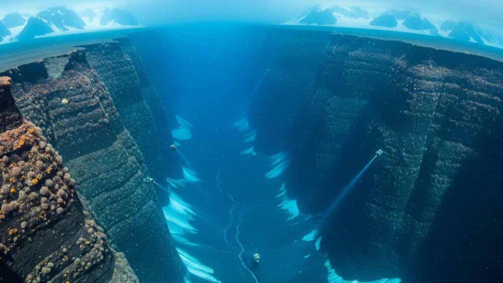
A groundbreaking seafloor atlas has revealed more than 300 previously unknown giant canyons beneath Antarctica’s ice, offering critical new insights into how ocean circulation, ice melt, and future sea-level rise may unfold.
The research, published in Marine Geology and led by the University of Barcelona in collaboration with University College Cork, compiles high-resolution data from over 40 expeditions. It is the first standardized continent-wide map of Antarctica’s margins, reducing major gaps in previous surveys.
Vast networks shaping water and ice flow
The atlas identifies 332 deep valleys, some plunging over 4,000 meters. These canyons act as conduits that transport water, sediments, and nutrients between the continental shelf and the deep Southern Ocean. Their role is crucial: salty, dense water formed on the shelf sinks along the slopes, driving global thermohaline circulation, while warm deep water can rise through the canyons to reach ice shelves, accelerating melting from below.
“Even subtle changes in these pathways can significantly impact melt rates and climate feedbacks,” said Dr. Alan Condron, one of the researchers involved.
Contrasts between East and West Antarctica
The new map also highlights stark differences in glacial history. East Antarctica’s canyon systems appear branched and extensive, suggesting long-term stability. In contrast, West Antarctica’s straighter and steeper valleys point to more dynamic, episodic ice loss, raising concerns about its vulnerability to rapid retreat under warming conditions.
A new baseline for climate models
Until now, many climate models treated the Antarctic seafloor as relatively smooth, underestimating how topography affects ocean currents and ice–ocean interactions. By incorporating canyon geometry, depth, and connectivity, scientists can now refine forecasts of where warm water will intrude and how quickly inland ice loss might contribute to rising seas.
Accurate topography is especially critical for coastal planning, where cities require realistic timelines for sea-level rise rather than broad estimates.
Unlocking past and future climate insights
Beyond present-day risks, the atlas provides a record of Antarctica’s ice and ocean behavior over millions of years. Coupled with sediment cores and geophysical data, the canyon structures will help reconstruct the history of glacial advances and retreats, offering clues about how ice responded to previous warming events.
The work also identifies priority areas for future research, particularly beneath major ice shelves where data remain scarce. Autonomous vehicles and advanced sonar missions are expected to fill these gaps.
Global stakes
The discovery underscores Antarctica’s central role in global climate. The canyon systems not only control how heat interacts with ice but also influence the movement of nutrients and carbon, shaping marine ecosystems.
“This atlas is more than just a map,” said Dr. David Amblàs of the University of Barcelona. “It’s a foundation for better predictions, better models, and ultimately, better decisions in the face of accelerating climate change.”
By revealing the hidden architecture beneath Antarctica, scientists hope to provide earlier warnings of ice loss and ocean shifts—giving policymakers and coastal communities more time to prepare for rising seas and changing climate dynamics.