


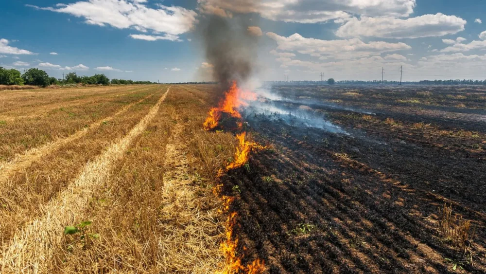
NASA scientists have issued a fresh warning about changing agricultural practices in northern India, noting that farmers are increasingly burning crop residue later in the day—a shift that is complicating satellite-based monitoring of stubble burning and obscuring its true impact on air quality.
For decades, seasonal crop fires across the Indo-Gangetic Plain—particularly in Punjab and Haryana—have been a major contributor to hazardous air pollution between October and December. The burning of rice stubble after harvest routinely blankets large parts of northern India, including Delhi, in dense smoke and haze. While the overall duration and intensity of the 2025 stubble-burning season largely followed historical trends, scientists say the timing of the fires has changed in a significant way.
“In many ways, the seasonal pattern looked familiar,” said Hiren Jethva, an atmospheric scientist at Morgan State University working with NASA’s Goddard Space Flight Center. “Air quality deteriorated in Delhi and several other cities for about a month after fires intensified in the last week of October.”
What stood out this year, however, was when the fires were set.
“For years, most stubble burning occurred in the early afternoon, typically between 1 p.m. and 2 p.m.,” Jethva explained. “Now, we are seeing a clear shift, with fires more likely to be lit between 4 p.m. and 6 p.m. Farmers have changed their behavior.”
Why Timing Matters for Satellites
This shift has important implications for how scientists track crop burning from space. Many widely used fire-monitoring satellites—such as MODIS and VIIRS—pass over the same location only once or twice a day. Fires ignited later in the afternoon or early evening are therefore more likely to be missed entirely, leading to undercounting and less accurate assessments of pollution sources.
The change was detected using data from South Korea’s GEO-KOMPSAT-2A, a geostationary satellite launched in late 2018 that collects observations every 10 minutes. Unlike polar-orbiting satellites, GEO-KOMPSAT-2A allows scientists to track the evolution of fires and smoke plumes throughout the day.
“This kind of high-frequency observation is revealing behavior that we simply couldn’t see clearly before,” Jethva said.
Severe Pollution Episodes Persist
Satellite imagery from November 11, 2025, illustrates the scale of the problem. NASA’s Aqua satellite captured a vast plume of smoke stretching across Punjab, Haryana, Uttar Pradesh, and Madhya Pradesh. Media reports from that period indicated that Delhi’s Air Quality Index (AQI) exceeded 400, the highest category on the scale, for the first time that year.
As in previous winters, authorities responded by closing schools in some regions and tightening restrictions on construction, vehicle use, and other pollution-generating activities. Scientists note that stagnant winds and unfavorable atmospheric conditions during this season can push pollution levels to several times above World Health Organization guidelines.
How Bad Was Stubble Burning in 2025?
NASA’s analysis suggests that crop burning in 2025 was moderate compared with recent years. Fire counts in Punjab and Haryana were higher than in 2024, 2020, and 2019, but lower than in 2021, 2022, and 2023.
Independent Indian studies support NASA’s findings. A 2025 paper published in Current Science found that peak fire activity shifted from around 1:30 p.m. in 2020 to nearly 5 p.m. by 2024, based on data from the Meteosat Second Generation satellite. In December 2025, researchers at the International Forum for Environment, Sustainability, & Technology released a multi-satellite analysis reaching similar conclusions.
How Much Does Stubble Burning Contribute to Delhi’s Pollution?
While the role of crop burning in northern India’s winter smog is widely acknowledged, scientists continue to debate how much it contributes relative to other sources such as vehicle emissions, industrial pollution, domestic cooking and heating, fireworks, and dust storms.
“Studies report contributions ranging anywhere from 10 to 50 percent,” said Pawan Gupta, a NASA research scientist specializing in air quality.
Gupta estimates that stubble burning can account for 40 to 70 percent of pollution on peak days, but that figure drops to 20 to 30 percent when averaged over a month, and less than 10 percent on an annual basis.
He emphasized that meteorological factors—such as low temperatures, weak winds, and a shallow atmospheric boundary layer during winter—play a critical role. “These conditions trap pollutants close to the ground, amplifying the impact of emissions from all sources,” Gupta said.
A New Challenge for Pollution Management
Scientists are particularly concerned that later-day fires could worsen overnight pollution buildup. Evening burns often coincide with calmer winds and atmospheric conditions that prevent smoke from dispersing, allowing pollutants to accumulate near the surface through the night and into the following morning.
“From an air-quality perspective, this timing shift matters,” Jethva noted. “Fires lit later in the day may have a disproportionate impact on nighttime and early-morning pollution levels.”
NASA researchers say understanding these behavioral changes is essential for improving pollution models, designing effective mitigation strategies, and informing policy decisions. As satellite technology advances, scientists hope better temporal coverage will help authorities respond more precisely to one of northern India’s most persistent environmental challenges.